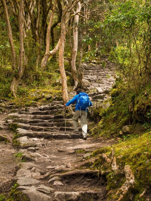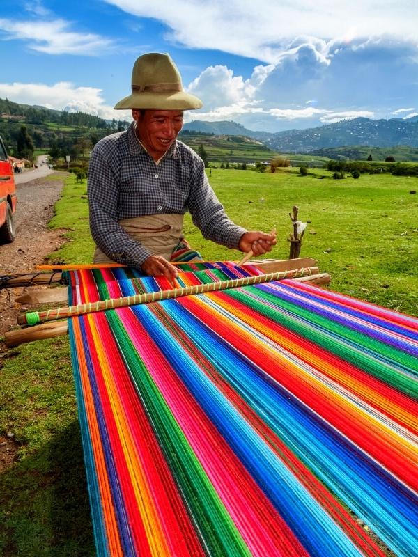
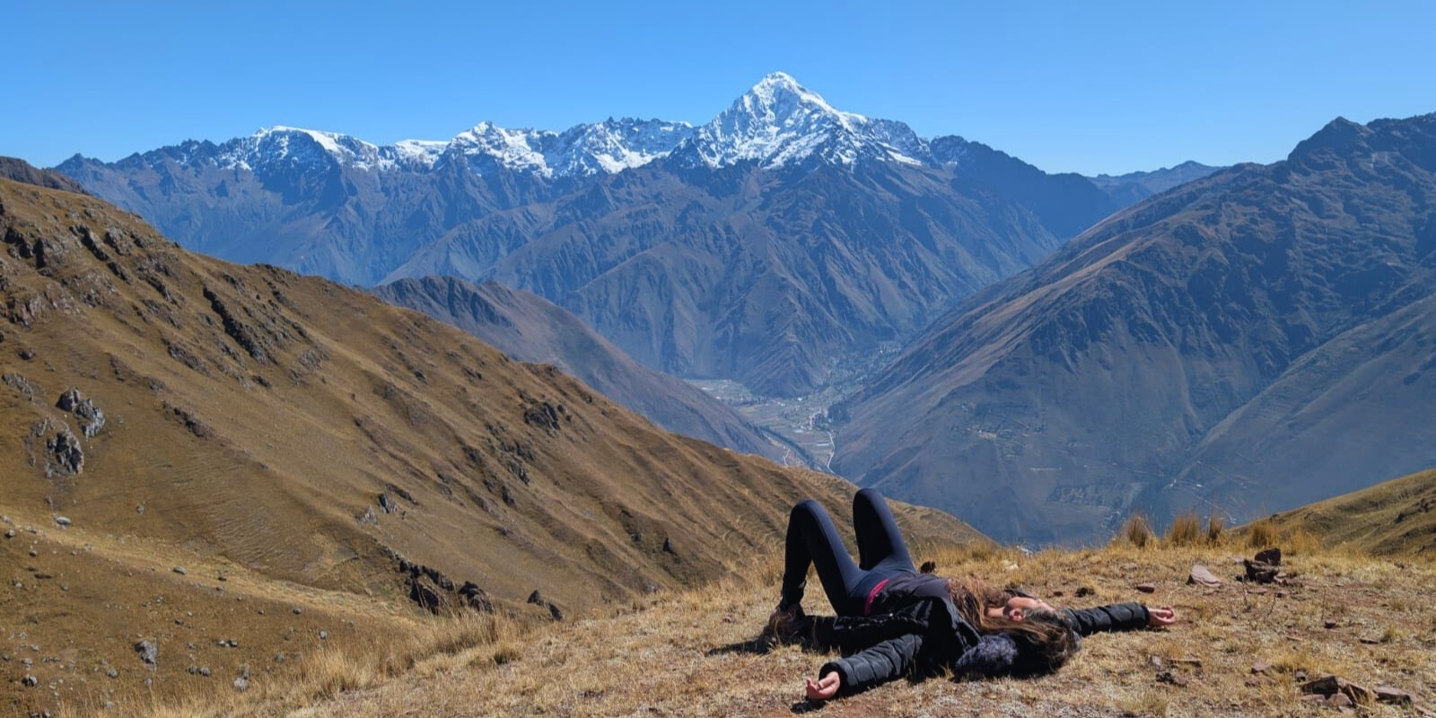
Peru stands as one of the world’s ultimate hiking destinations, boasting an extraordinary mix of ancient Inca pathways, towering Andean peaks, lush cloud forests, and dramatic desert canyons. The legendary Inca Trail remains the crown jewel, a four-day journey through mystical archaeological sites like Wiñay Wayna before revealing the sunrise over Machu Picchu—an experience that blends physical challenge with profound historical wonder. The best Hiking Trails in Peru, offers a divers sceneries of travelling. What makes Peru’s trails truly unique is their cultural richness; many routes pass through traditional Quechua villages, where hikers can connect with local communities and learn about centuries-old Andean traditions.
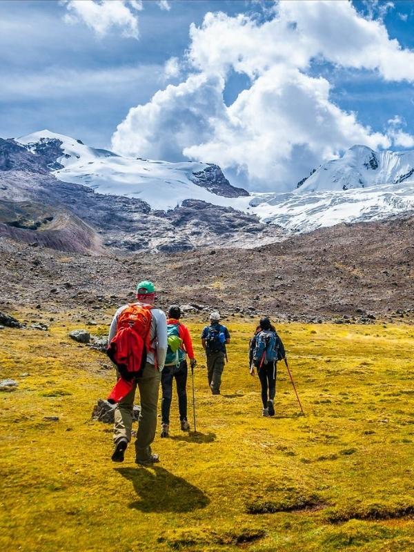
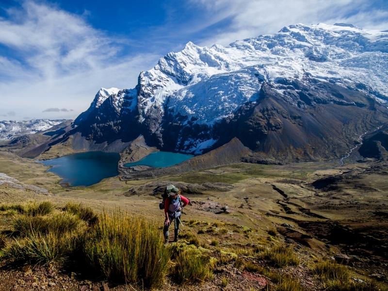
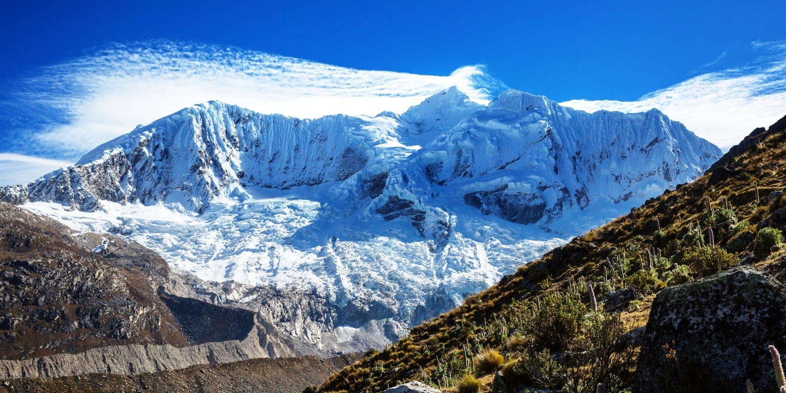
For adventurers craving remote, high-altitude expeditions, the Cordillera Huayhuash Circuit is a world-class trek, often ranked among the most stunning on the planet. This 8-12 day journey circles razor-edge peaks like Yerupajá (6,617m), passes crystalline alpine lakes such as Laguna Jahuacocha, and crosses Andean passes above 5,000 meters—best suited for experienced trekkers. Equally breathtaking but slightly more accessible, the Ausangate Trek takes hikers around Mount Ausangate (6,384m), where surreal landscapes include the Vinicunca Rainbow Mountain, a natural wonder of striped mineral colors. This route also intertwines with Andean spirituality, as locals consider Ausangate a sacred apu (mountain deity) and perform traditional offerings along the trail.
Beyond the Andes, Peru’s hiking diversity astounds—from the deepest canyons to coastal desert trails. The Santa Cruz Trek in Huaraz delivers glacial panoramas in the Cordillera Blanca, including views of Alpamayo, often called “the world’s most beautiful mountain.” Meanwhile, the Colca Canyon Trek plunges hikers into a 3,270-meter-deep chasm, where Andean condors soar above terraced pre-Inca farms. For something entirely different, the Choquequirao Trek leads to the “sister city” of Machu Picchu, an isolated Inca ruin with only a fraction of the crowds. Whether you seek Inca history, extreme altitude, wildlife encounters, or cultural immersion, Peru’s trails offer unrivaled variety—each with its own story, challenge, and breathtaking payoff.
Jumping off point: Cusco
Duration: 4 Days
Distance: Approx. 28 miles (45 km)
Rating: Moderate to difficult
Elevation: 3,110 m – 10,203 feet
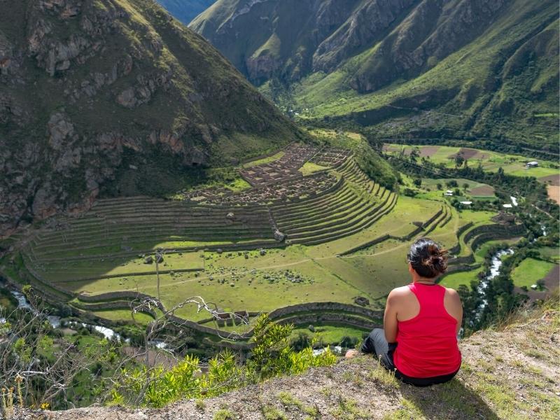
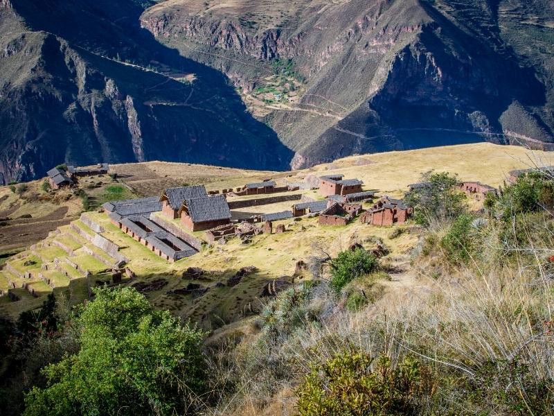
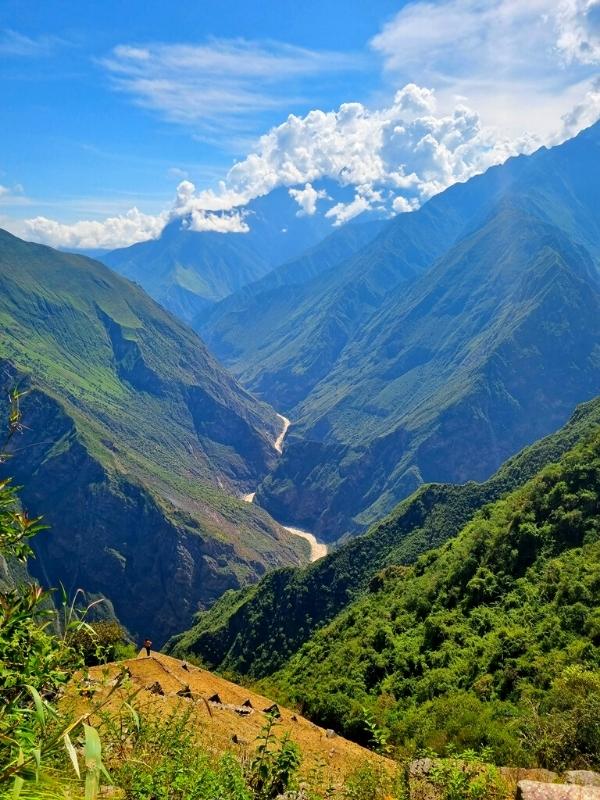
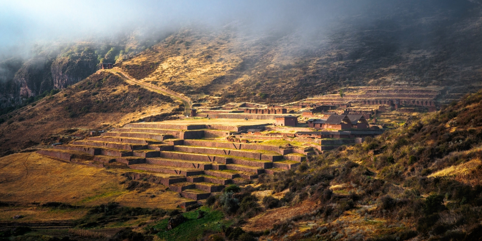
The Choquequirao Trek is a hidden gem among hiking trails in Peru. The trek to Choquequirao is physically demanding but offers a rare opportunity to explore this vast archaeological complex without the crowds. The hike to Choquequirao is considered one of the best by National Geographic magazine. This is because this Peruvian tourist attraction is rarely visited, but it is a unique place that offers breathtaking views of the Andean landscape. The ruins of Choquequirao were built by the Inca Empire more than 500 years ago. This famous site is located above the Apurimac River canyon, nestled in a lush Andean forest teeming with flora and fauna. It is currently accessible through specialized agencies from the city of Cusco. From the beginning, you can hike along the foothills of the Apurimac River canyon, where you may spot condors.
This descent to the bottom of the canyon is quite easy along a dusty, hot path. Then, you ascend to the town of Marampata, where you can enjoy the best sunrises and sunsets; the views are fabulous. The archaeological complex is enormous, with less than 30% of its remains discovered, yet it will take you most of the day to explore. Each section features long, steep terraces. The most notable is the Llamas section, where the terraces are built with white stones resembling llamas. These stones were necessary for transporting goods in Inca times. After a rewarding experience, you will return to the Capuliyoq viewpoint, where visitors will be picked up for the return trip to Cusco. This hike is recommended only for those in good physical condition and accustomed to walking on steep terrain. The most difficult aspect of the trek is perhaps the heat and the steep terrain on the way up and back. It is not recommended to go on your own, as this site does not have easily accessible emergency points. It is also not a good idea to go during the rainy season, which is from December to March, as landslides and rock slides are common.
Flora and Fauna: This trek goes through cloud forest, high jungle and alpine terrain, so you can see an amazing variety of plant life and animals. Spot Andean deer, condors, hummingbirds, butterflies, Andean condors and maybe even the spectacled bear among the orchids, violets, fruit trees and lush green vegetation.
Magnific Inca Architecture: This site is amazing because there are far fewer tourists but it’s just as amazing a ruin as Machu Picchu. Located in the canyon of the Apurimac River, this ancient citadel comprises 12 sectors including ceremonial, residential, astronomic, plaza, llama and food storage sectors.
Impressive Landscape: Exploring the ruins of Choquequirao, trekking through cloud forests, and possibly spotting condors soaring above the valley. Terraced farmlands that trace the edge of the canyon’s namesake river eventually give way to an exhilarating shift from vertical desert to high-altitude jungle as hikers climb their way to the site.
Best off beaten trails in Cusco: Authentic and uncrowded, Choquequirao is the more challenging and isolated alternative to Machu Picchu for avid hikers seeking a route steeped in Inca history.
Jumping off point: Cusco
Duration: 6 to 8 Days
Distance: Approx. 59 miles (95 km)
Rating: Moderate to difficult
Elevation: 4300 m – 14,107 feet
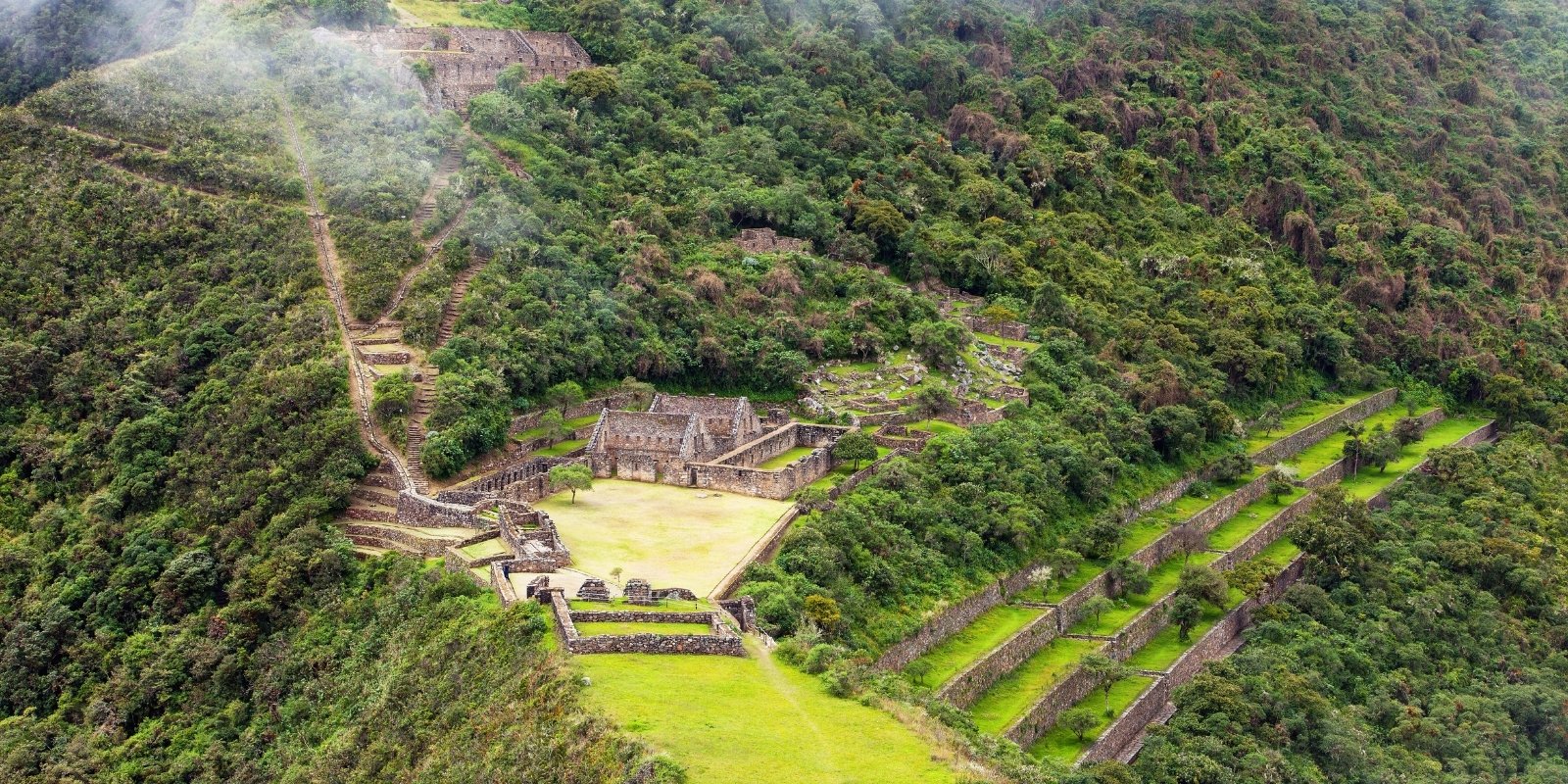
This lesser-known trek beholds everything you’d wish for on an Andean adventure: Inca ruins, snow-capped mountains, green river valleys, high jungle and even semi-tropical rainforests, without the crowds. On the Vilcabamba Trek, you’ll traverse some of the most beautiful parts of the Vilcabamba mountain range, making your way to the Vilcabamba ruins embedded in the lush jungle. This trek launches from the city Cusco, where you’ll take a transfer to the village of Cachora to start toward your first archaeological sites of Choquequirao. After coursing through mountain passes, valleys and rainforests you make your way to Vitkos and Rosaspata Ruins on the final days.
If you’re looking for a hike without crowds and filled with breathtaking scenery, this Vilcabamba route is recommended for you. It’s recommended to hire the services of an authorized travel agency, as the distance and logistics involved in embarking on this adventure warrant a full range of insurance. During the more than seven days you trek through these mountains, you’ll traverse the Vilcabamba mountain range with the support of your guide, cook, and muleteers. Visiting is recommended from April to October, when you’ll enjoy good weather. This route is only available to tourists with extensive experience in long-distance hikes and varied terrain.
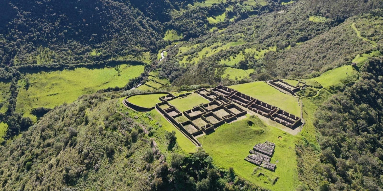
Unique wild places: Wildly remote, with a stunning section of Inca Trail, this is a top hike in Cusco. This is one of the most beautiful hikes in Cusco, as you’ll explore the route that connects the archaeological sites of Choquequirao and Vitkos, where the last Incas took refuge. The landscape surrounding this hike ranges from the Andes to tropical valleys filled with wildflowers and birds endemic to Peru.
Original Inca Trail: The Inca trail becomes clear at Quelcamachay, taking you over the pass and down into the valley on the other side. Before reaching Vitcos, you’ll come across a huge, carved rock called Ñustahispana, and a system of fountains.
Cultural wealth: The Vilcabamba Trek is a historical hike that traces the path of the last Inca resistance. This remote and challenging trail takes hikers through lush jungles and high Andean passes to the Vilcabamba ruins, where the last Inca emperor, Manco Inca, retreated during the Spanish conquest.
Jumping off point: Cusco
Duration: 4 to 7 Days
Distance: Approx. 50 miles (80 km)
Rating: Moderate to difficult
Elevation: Between 15,090 feet (4,600 meters) and 17,716 feet (5,400 meters)
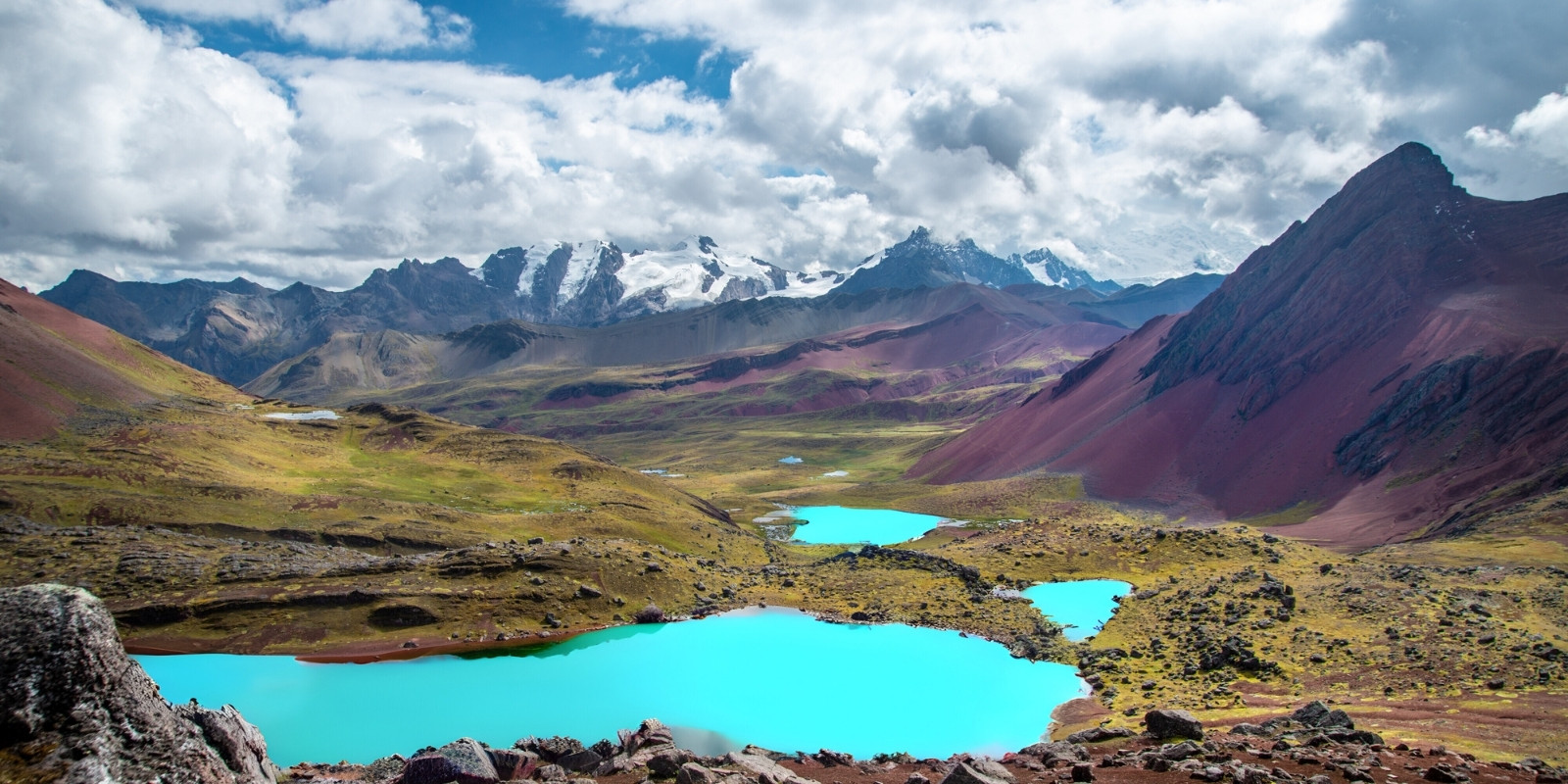
Ausangate Mountain is considered by the people of the Andes to be a holy mountain. It is also the fifth highest mountain in Peru at 20,945 ft (6,384 m). If you’re looking for one of the most visually stunning and remote hiking trails in Peru, the Ausangate Trek is the ultimate adventure. This high-altitude trek circles the Ausangate Mountain, the fifth-highest peak in Peru, and offers views of rainbow-colored mountains, glacial lakes, and vast alpine landscapes. This trail is for serious hikers seeking solitude and dramatic natural beauty. The trek launches from the city of Cusco and the trailhead is in the village of Upis. On this hike you’ll traverse around grasslands, valleys, lakes and mountain passes; and circle near Ausangate about halfway through. The trek actually ends in the town of Pacchanta.
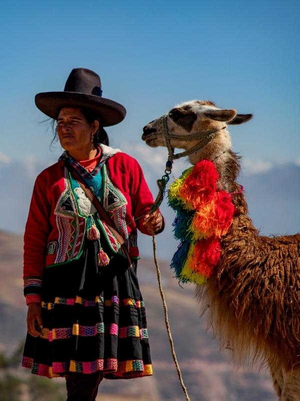
This route is a real challenge for hikers due to the high altitudes at which it is traversed, but with a good acclimatization program, anything is feasible. Aside from its great natural and scenic appeal, the Ausangate circuit offers a glimpse into various Quechua communities, dedicated to herding alpacas and llamas, whose wool they use to make beautiful handicrafts with unique and fine designs. The valleys also produce the best organic potatoes in Cusco, and its lakes are stocked with trout, which they sell to hikers.
The best season to hike the Ausangate Trek and the Rainbow Mountains is from May to October. During this time, hikers can enjoy clear skies and minimal rainfall. Like any high-altitude area, it can be very cold in the mornings and evenings, so it is advisable to wear good thermal clothing. If you venture out on your own, it’s important to know that there are no nearby communities on this circuit. If something happens to you, you should hire the services of a tour operator with many years of experience and good high-mountain camping equipment for your own safety.
Abra Palomani Pass: This is the highest pass of the trek, taking you to a soaring 17700 ft above sea level. From here you’ll get unique views of Ausangate and the whole Vilcanota Range.
Pacchanta Hot Springs: On the last day, after a challenging hike with elevations reaching 17000 feet, you can reward yourself in the Pacchanta Hot Springs. These mineral rich thermal baths can soothe your muscles and relax your mind.
Rainbow mountains: The natural attraction of the rainbow mountains is unparalleled. When you visit Vinicuna Mountain, you’ll enjoy the magic of the Andes. Another highly recommended spot is the Red Valley viewpoint, where the scenery is absolutely beautiful and sure to leave you speechless.
Turquoise lakes: Ausangate and Rainbow Mountain trek is one of the best hikes in Peru with landscapes that will have your camera working overtime. The lakes gleam turquoise, the green valleys are awash with alpaca herds.
Ausangate Glacier: Throughout the entire route, the Ausangate Glacier offers you diverse views. In fact, the best panoramic photos you can take are when ascending the Pucapunta Pass, from where you have an impressive view of the glacier and its light blue and turquoise lagoons.
Jumping off point: Cusco
Duration: 4 Days
Distance: Approx. 28 miles (45 km)
Rating: Moderate to difficult
Elevation: Between 9,180 feet (2,800 meters) and 13,780 feet (4,200 meters)
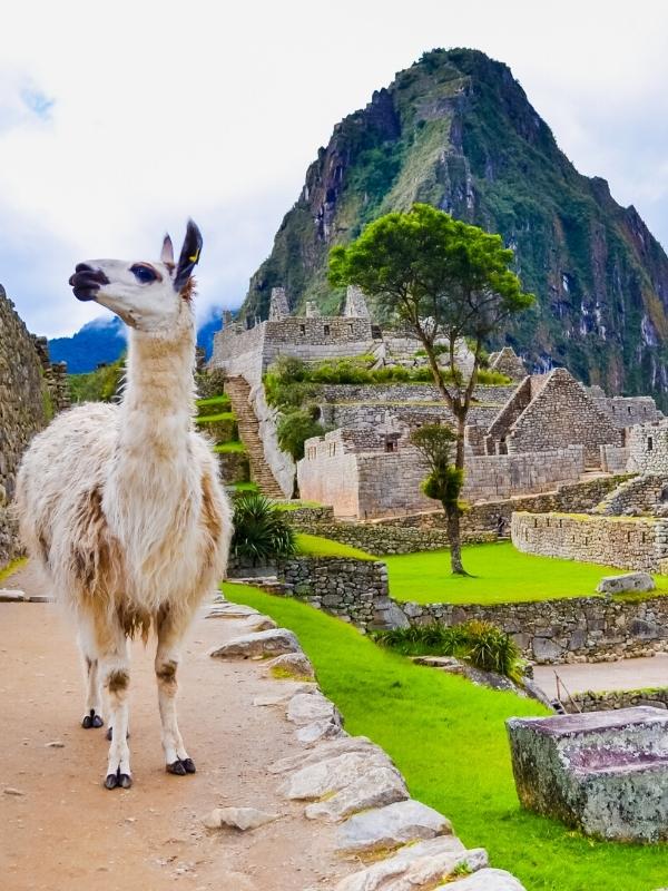
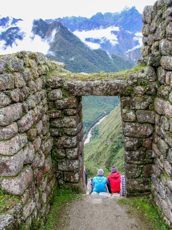
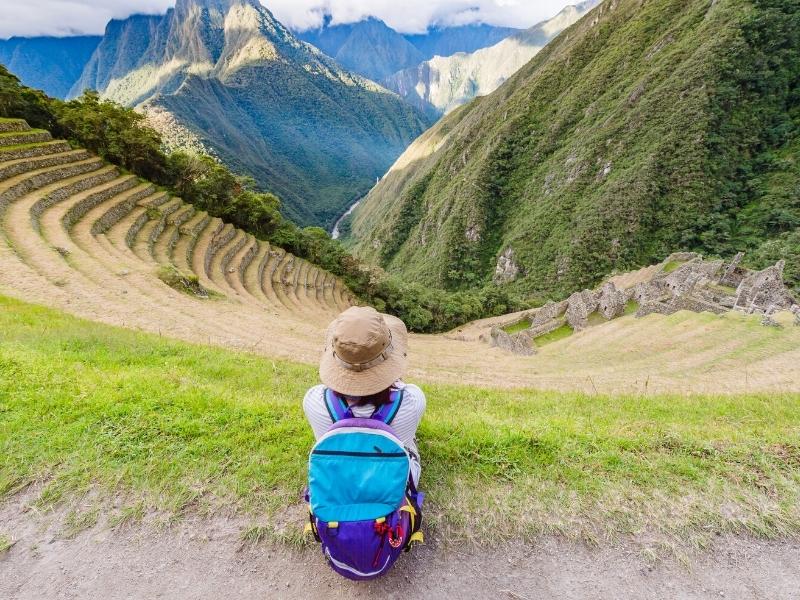
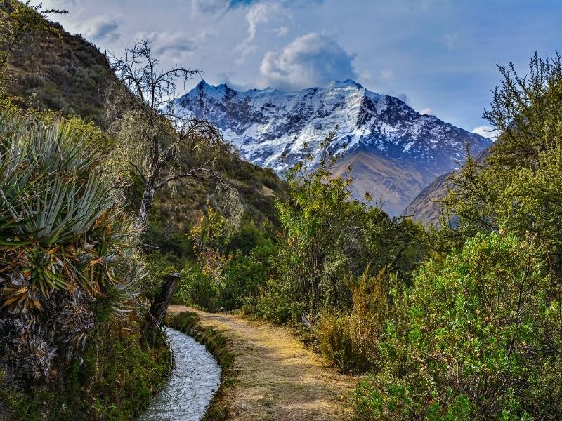
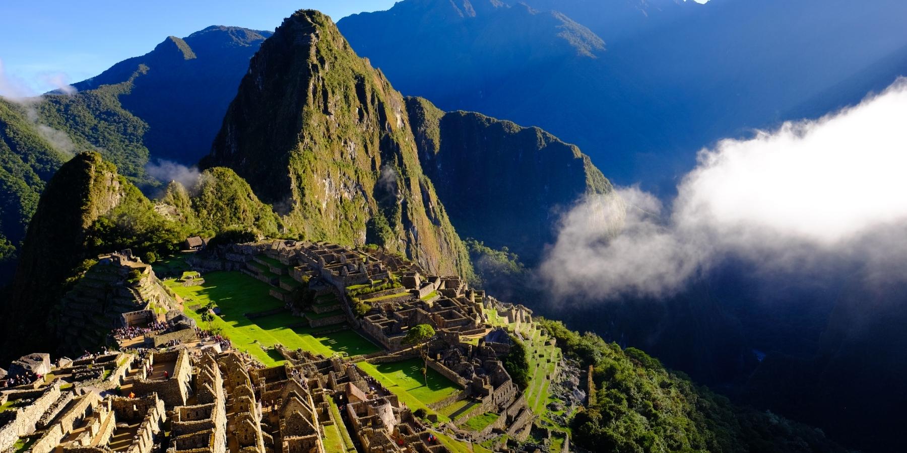
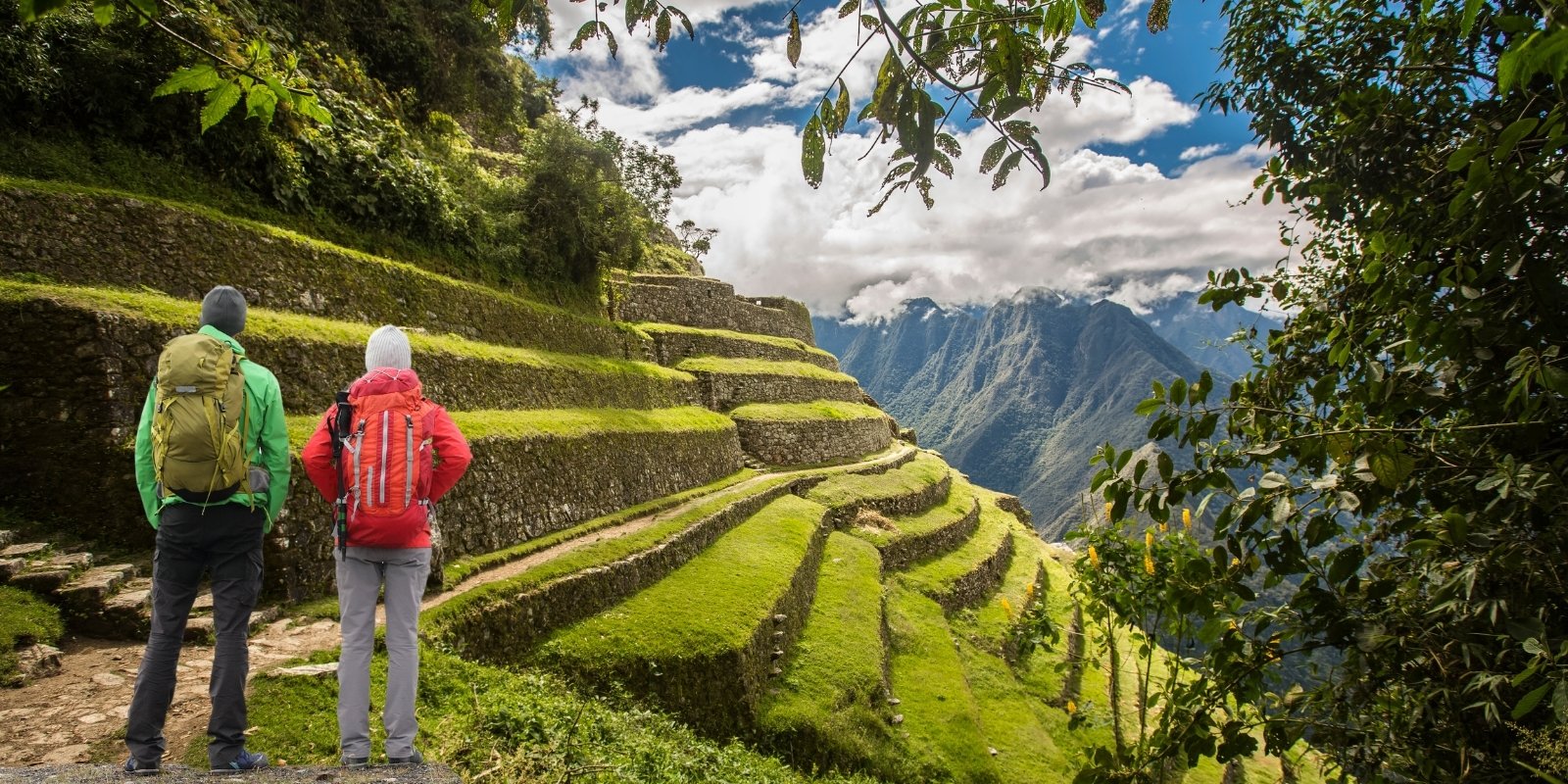
The classic Inca trail is considered one of the top 10 in the world. Hikers from all over the globe flock to this popular trek, which must be booked at least 6 months in advance during high season as permits sell out quickly. This trail is a protected archaeological site, with precious ruins and beautiful Andean scenery throughout. The Inca Trail starts from Cusco and the trailhead is in the village of Piscacucho. From there, you’ll course past river valleys, alpine tundra, lush cloud forests, archaeological sites, and ancient tunnels and stairways. Finally on day 4 you’ll enter Machu Picchu through the Inti Punku, or Sun Gate, to start your exploration of the famed ruins. The variety of natural landscapes and ancient ruins make this one of the best treks in Peru.
Currently, this trek is only possible with an authorized tour operator. It is recommended to go in a small group so you can fully enjoy the landscape and Inca ruins. The porters are in charge of carrying your luggage. They are residents of the surrounding communities. A very gratifying reason for taking this route is that you will truly be supporting the community members, who, thanks to your visit, earn a decent wage.
The best time to visit the Inca Trail to Machu Picchu is from April to October. During these months, you will enjoy beautiful sunsets and sunrises, and there is not much rainfall. It is recommended to prepare well in advance, as the second day of the hike will be a real challenge, crossing the highest pass of the trek (4,200 m). The stone steps that the Incas built along the 45 km Inca Trail to Machu Picchu are also a great challenge. Consider bringing good trekking poles; these will help you maintain balance and protect your knees and ankles.
Patallacta Ruins: Is a very interesting Incan Archaeological site. Translated from Quechua, Patallacta means “settlement on a platform,” and the ruins are indeed that. It is a raised site of about 100 houses, plus terraces and a shrine for ritual ceremonies that you’ll see on day one.
Dead Woman’s Pass: This is the highest pass of the trek at 13,828 feet (4,214 m) above sea level. Though the ascent is challenging, you’ll be awarded gorgeous vistas of Wayanay mountain, Huayllabamba valley and Pacaymayu.
Sayacmarca Ruins: Its name means “inaccessible town” due to its strategic location atop a mountain, surrounded by cliffs. This structure would have been an administrative, religious, and military center, with terraces, plazas, water channels, and finely carved stone buildings. Its design, adapted to the mountainous terrain, demonstrates advanced Inca engineering.
Phuyupatamarca Ruins: Which means “Town in the Clouds,” is a very special ancient town that you’ll pass on your way to Machu Picchu. It is characterized by irrigation systems, terraces and ritual baths once used by Inca priests. It is believed this site was a place of worship to water.
Intipata ruins: Its name means “place of the sun” in Quechua, and it is characterized by its large agricultural terraces built on a steep hillside. These terraces would have been used for farming, taking advantage of the area’s sun exposure and favorable climate. The design demonstrates advanced Inca agricultural engineering, with well-preserved drainage systems and retaining walls. Its location offers stunning views of the valley and the Urubamba River.
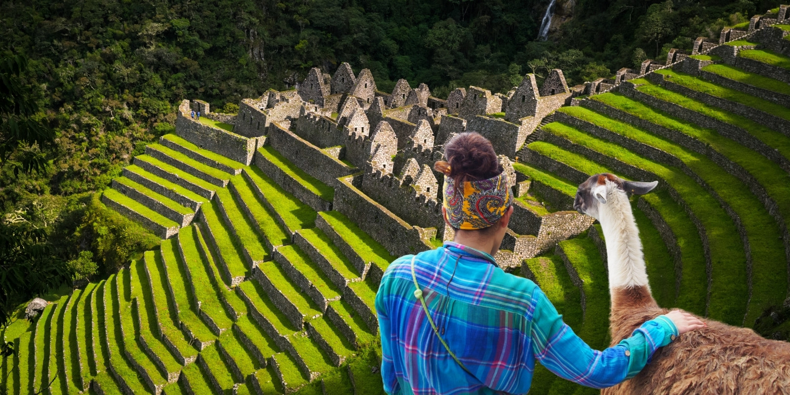
Wiñay Wayna Ruins: This beloved archaeological site is also the location of your campsite on your final night. Wiñay Wayna translates from Quechua to Forever Young. This impressive Inca construction was built on a steep hill overlooking the Urubamba River.
Jumping off point: Cusco
Duration: 4 Days
Distance: Approx. 18 miles (30 km)
Rating: Moderate to difficult
Elevation: Between 9,180 feet (2,800 meters) and 15,680 feet (4,780 meters)
The Lares Trek is an alternative hike to Machu Picchu, especially for lovers of culture. This 4-day hike takes you through the mountains, valleys and villages that lead you to the famous citadel. It’s an excellent option for adventurers who would also like more insight into traditional Andean cultures and how locals have adapted to the modern day, all while preserving and honoring their ancient heritage. The hike starts from Cusco then takes off from the trailhead in the charming Lares Village. The trek begins by weaving through the Lares Valley, coursing high mountain passes, traditional weaving towns and picturesque lakes. It then reaches the town of Ollantaytambo, known for its ancient Inca fortress, then continues onto Aguas Calientes. After a night relaxing at an Aguas Calientes hotel, you can get rested and ready for your tour of Machu Picchu.
This Lares route has been one of the best options for visitors wishing to explore the Andes and its cultures. The best time to visit is from April to October, when Cusco enjoys good weather. It is understood that, as in any high-mountain location, you should bring good trekking gear to protect yourself from the cold and sunlight during the day. The equipment is carried by mules and horses. The local guides in Cusco will offer impeccable service and provide you with the information you need. It is advisable to acclimatize at least three days before beginning the hike. Many of the villages you pass through are Quechua villages, dedicated to organic potato farming and alpaca herding. They speak only Quechua and a little Spanish.
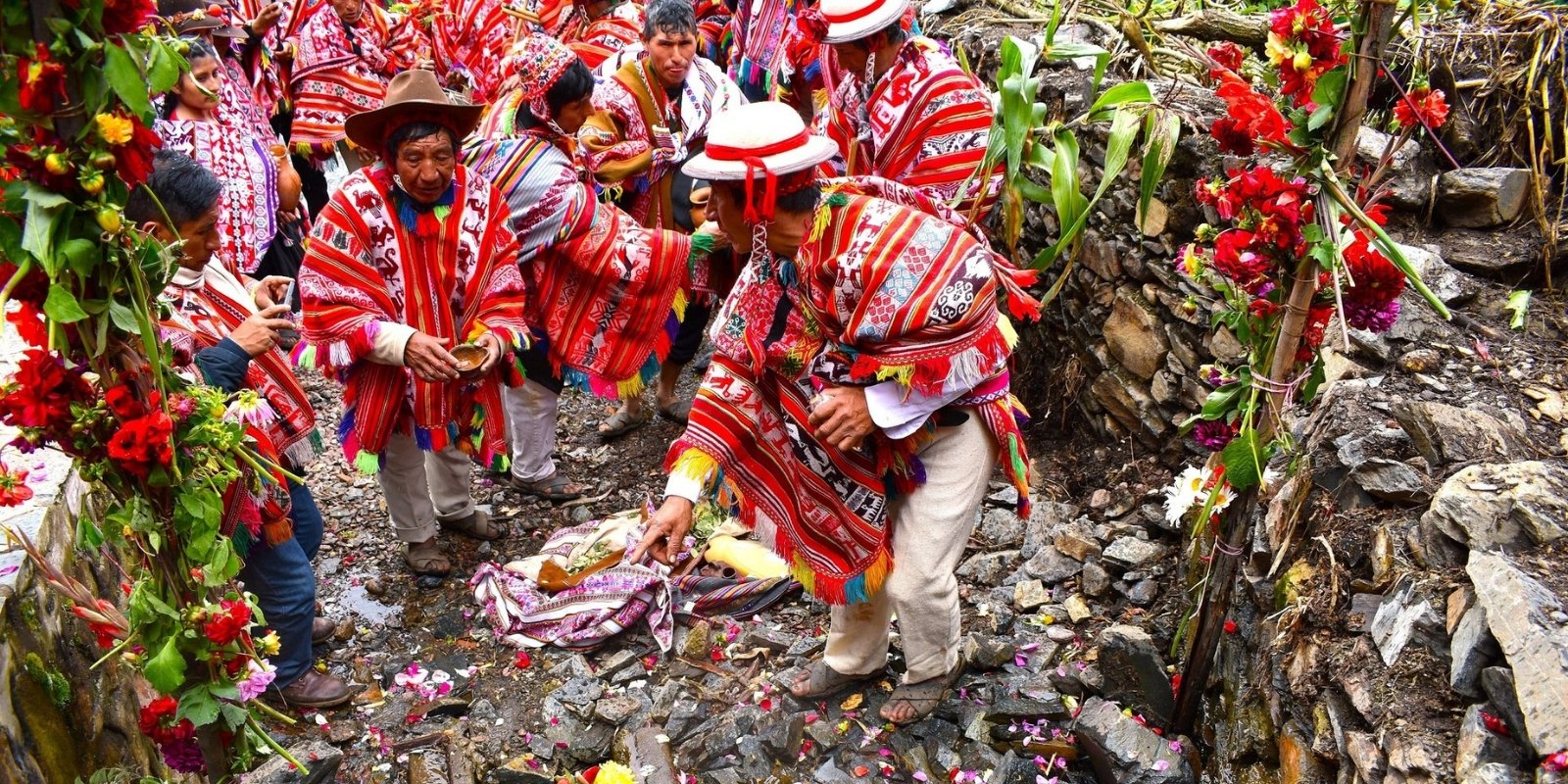
Andean Villages: Lares Trek offers the perfect blend of beautiful landscapes and interactions with traditional Andean communities. This off-the-beaten-path hike takes you through remote villages where you can witness centuries-old weaving traditions, meet local Quechua families. You will be visiting Andean villages, meeting local residents and learning about their traditional ways of life. You’ll also see their beautiful handcrafts.
Sikllacasa Pass: On day 2 you reach the highest point of the trek. Sikllacasa Pass is 15,680 feet above sea level and provides a gorgeous view of the surrounding mountains before your descent into the remote town of Urubamba.
Machu Picchu: On day 4 you will tour the Machu Picchu citadel. See the iconic ruins, snap the perfect picture and even opt for a hike within Machu Picchu to Huayna Picchu or Machu Picchu Mountain (permits must be reserved far in advance).
Thermal pools: Along the Lares Trail, there are yellow hot spring pools with varying temperatures, providing visitors with a place to relax before or after hiking. It’s recommended that you bring your own swimwear and a towel.
Jumping off point: Cusco
Duration: 4 Days
Distance: Approx. 16 miles (26 km)
Rating: Moderate to difficult
Elevation: Between 9,210 feet (2,810 meters) and 13,450 feet (4,100 meters)
The Inca Quarry Trail, an alternative to the classic Inca Trail, is a lesser-known but equally impressive trekking route that takes you through spectacular Andean landscapes in the Cusco region of Peru. This trail combines history, nature, and adventure, taking you through ancient Inca quarries, where stones were extracted to build sites like Ollantaytambo. Unlike the traditional Inca Trail, this route offers a more peaceful experience, with fewer tourists and panoramic views of snow-capped mountains, verdant valleys, and hidden archaeological ruins.
Trekking the Inca Quarry Trail typically takes four days, starting in the town of Socma, descending to the Cachicata quarry at over 4,000 meters above sea level, and culminating in Machu Picchu. During the journey, hikers cross valleys, mountains, and Inca ruins, pass by waterfalls like Perolniyoc, and explore less-visited archaeological sites, such as the Raqaypata terraces. Nights are spent in campsites under starry skies, surrounded by the majesty of the Andes. The route requires a good level of fitness due to the steep climbs and altitude, but the reward is unique views of the Vilcabamba Mountains and a closer connection with Inca culture.
One of the advantages of the Inca Quarry Trail is that it doesn’t require a special permit, unlike the Inca Trail, which has limited capacity. This makes it an excellent option for adventure seekers without much advance planning. The tour also includes encounters with local communities, where you can learn about Andean traditions and ancient agriculture.
Soqma Community: This is a small village located near Ollantaytambo. This farming community maintains ancestral traditions, growing corn, potatoes, and other typical local produce. Soqma stands out for its natural surroundings and its connection to Inca archaeological sites. The inhabitants preserve their Quechua culture, offering visitors an authentic experience of the Andean way of life. It is an ideal place for those seeking rural tourism and trekking off the beaten path.
Perolniyoq Waterfall: The Perolniyoc Waterfall is an impressive waterfall approximately 30 meters high, located near the community of Soqma. To reach it, it is a 1.5 to 2-hour hike from Soqma, passing through Andean landscapes, Inca agricultural terraces, and small streams. This waterfall is known for its natural beauty and refreshing energy, making it a key stop on the Quarry Trail.
Raqaypata Ruins: The Raqaypata ruins, located near the community of Soqma in the Sacred Valley (at 3,700 meters above sea level), are a rarely visited Inca archaeological site. This complex, linked to the Cachicata quarries, would have functioned as an administrative and agricultural center, with cultivation terraces, ceremonial structures, and well-preserved stone walls, offering spectacular views without the crowds of more touristy sites.
Inca Gate Viewpoint: The Sun Gate, located at over 3,800 meters above sea level near Ollantaytambo, is an impressive stone structure associated with the ancient Inca quarries from which the pink stone blocks were extracted to build the Temple of the Sun in Ollantaytambo. This site offers panoramic views of the Urubamba River Valley and the Vilcabamba mountain range. Its trapezoidal design and strategic location reflect the Inca mastery of astronomy and sacred topography; it is a solitary setting filled with ancestral energy.
Inca Quarry of Cachiqata: Located near Ollantaytambo in the Sacred Valley, these quarries were an important center for the extraction of pink stone used to build the Temple of the Sun and other Inca monuments. These quarries, located at over 3,800 meters above sea level, display enormous semi-carved blocks abandoned during transportation, revealing the advanced engineering and logistics techniques of the Inca.
Jumping off point: Cusco
Duration: 2 Days
Distance: Approx. 10 miles (16 km)
Rating: Moderate
Elevation: Between 9,210 feet (2,959 meters) and 13,934 feet (4,247 meters)
The Huchuy Qosqo trek is a fascinating hiking route that combines Andean landscapes, Inca history, and living culture in a moderately difficult hike. This trek, which generally takes 2 or 3 days, departs from the town of Tauca (near Lamay) or Tambomachay (near Cusco) and culminates at the archaeological site of Huchuy Qosqo (“Little Cusco”), at an altitude of approximately 3,600 meters. Unlike more popular routes like the Inca Trail, this trek offers a more intimate experience with nature and local traditions, passing through valleys, lagoons, and rural communities where time seems to stand still.
The route stands out for its diverse scenery: from impressive snow-capped mountains like Pitusiray, Sawasiray, and Chicon to the peaceful lagoons of Piuray and Qoricocha. Hikers cross the Pucac’asa Pass (4,200 meters above sea level), an altitude challenge rewarded with panoramic views of the Andes, before descending into the Vilcanota River valley. Huchuy Qosqo, the final destination, is an Inca archaeological complex with stone and adobe buildings, agricultural terraces, and an intact hydraulic system. It would have served as an administrative and recreational center for the Inca nobility.
This trek is ideal for those seeking an authentic, less crowded alternative near Cusco, with opportunities to interact with Quechua communities and learn about their daily lives. No special permits are required (unlike the Inca Trail), but a guide is recommended due to the poorly marked trails. The best time to hike is during the dry season (April to October), when the skies are clear and the trails are free of mud. With its blend of adventure, archaeology, and culture, the Huchuy Qosqo trek is a hidden gem that reveals the lesser-known splendor of the Inca Empire.
Patabamba Village: Located at 3,800 meters above sea level in the Sacred Valley of Cusco, this traditional Quechua community is known for preserving its ancestral customs, artisanal weaving techniques, and Andean agriculture. Surrounded by stunning mountain landscapes, Inca terraces, and natural viewpoints, this destination offers an authentic rural experience, where visitors can participate in ancestral rituals and learn about handmade textiles using pre-Hispanic techniques.
Inca Ruins of Huchuy Qosqo: Located at 3,600 meters above sea level in the Sacred Valley near Lamay, this site was allegedly an administrative center and royal palace built by the Inca Wiracocha in the 15th century. Highlights include impressive two-story stone and adobe structures, agricultural terraces, warehouses, and a sophisticated hydraulic system, all integrated into a mountainous landscape overlooking the Vilcanota River.
Calca and the Sacred Valley of the Incas: Calca, located in the heart of the Sacred Valley of the Incas (at 2,900 meters above sea level), is a picturesque Andean town surrounded by towering mountains, rivers, and archaeological remains. It is known for its mild climate, medicinal hot springs, and vibrant local market, where Quechua traditions are preserved. This area, strategically cultivated by the Incas thanks to its fertile lands, combines history, spectacular landscapes, and an authentic, living culture.
Jumping off point: Huaraz
Duration: 12 Days
Distance: Approx. 76 miles (120 km)
Rating: Strenuous
Elevation: Between 10,800 feet (3,300- meters) and 17,500 feet (5,350 meters)
The Huayhuash Trek is one of the world’s most spectacular hiking trails, located in the Huayhuash mountain range in the Peruvian Andes. This circuit, which typically lasts between 8 and 12 days, offers breathtaking landscapes of snow-capped mountains, turquoise lagoons, and remote valleys. Unlike the more popular Inca Trail, the Huayhuash Trek is a more demanding and solitary experience, ideal for those seeking adventure and connection with nature in its purest form.
The route crosses high mountain passes that exceed 5,000 meters in altitude, such as the legendary San Antonio Pass, and allows close-up views of iconic peaks such as Yerupajá (6,617 m) and Siulá Grande (6,344 m). Hikers camp near crystal-clear lagoons such as Laguna Jahuacocha, a perfect place to rest and enjoy the reflection of the mountains in the water. Local wildlife, including vizcachas, condors, and alpacas, accompanies the journey, adding magic to the trip.
Although the Huayhuash Trek is an unforgettable experience, it is not without its challenges: altitude sickness, unpredictable weather, and lack of infrastructure require good physical and logistical preparation. It is recommended to travel with local guides or specialized agencies, as the terrain is remote and signage is scarce. Despite the difficulties, the rewards are incomparable: one of the most beautiful and authentic routes on the planet, reserved for the most daring adventurers.
Yerupaja Mountain: Yerupajá (6,617 m), the second highest mountain in Peru and the highest in the Huayhuash mountain range, is a colossus of ice and rock known for its imposing beauty and extreme technical difficulty. Nicknamed “The Butcher” for its treacherous nature, it attracts expert climbers, especially on its southern route, one of the most challenging in the Andes. Its proximity to glacial lakes and its sharp profile make it an icon of trekking and mountaineering in Peru.
Siula Peak: Siulá Grande (6,344 m) is an imposing mountain located in the Huayhuash mountain range, near Huaraz, Peru. It is famous for its pyramidal shape and challenging climbing routes, especially the west face. This summit attracts experienced climbers due to its technical difficulty and extreme weather conditions.
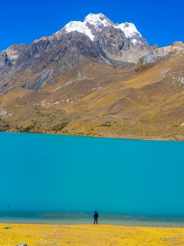
Lake Viconga: Lake Viconga is a stunning glacial lagoon located in the Huayhuash mountain range, at over 4,400 meters above sea level, known for its turquoise waters and the reflection of the surrounding snow-capped mountains, such as Puscanturpa and Cuyoc. It is a key stop on the Huayhuash Trek, where hikers often camp and enjoy nearby hot springs, ideal for relaxing after days of demanding trekking. Its remote setting and wild beauty make it one of the most memorable landscapes on the route.
Jumping off point: Huaraz
Duration: 4 Days
Distance: Approx. 28 miles (45 km)
Rating: Moderate
Elevation: Between 9,514 feet (2,900- meters) and 15,584 feet (4,750 meters)
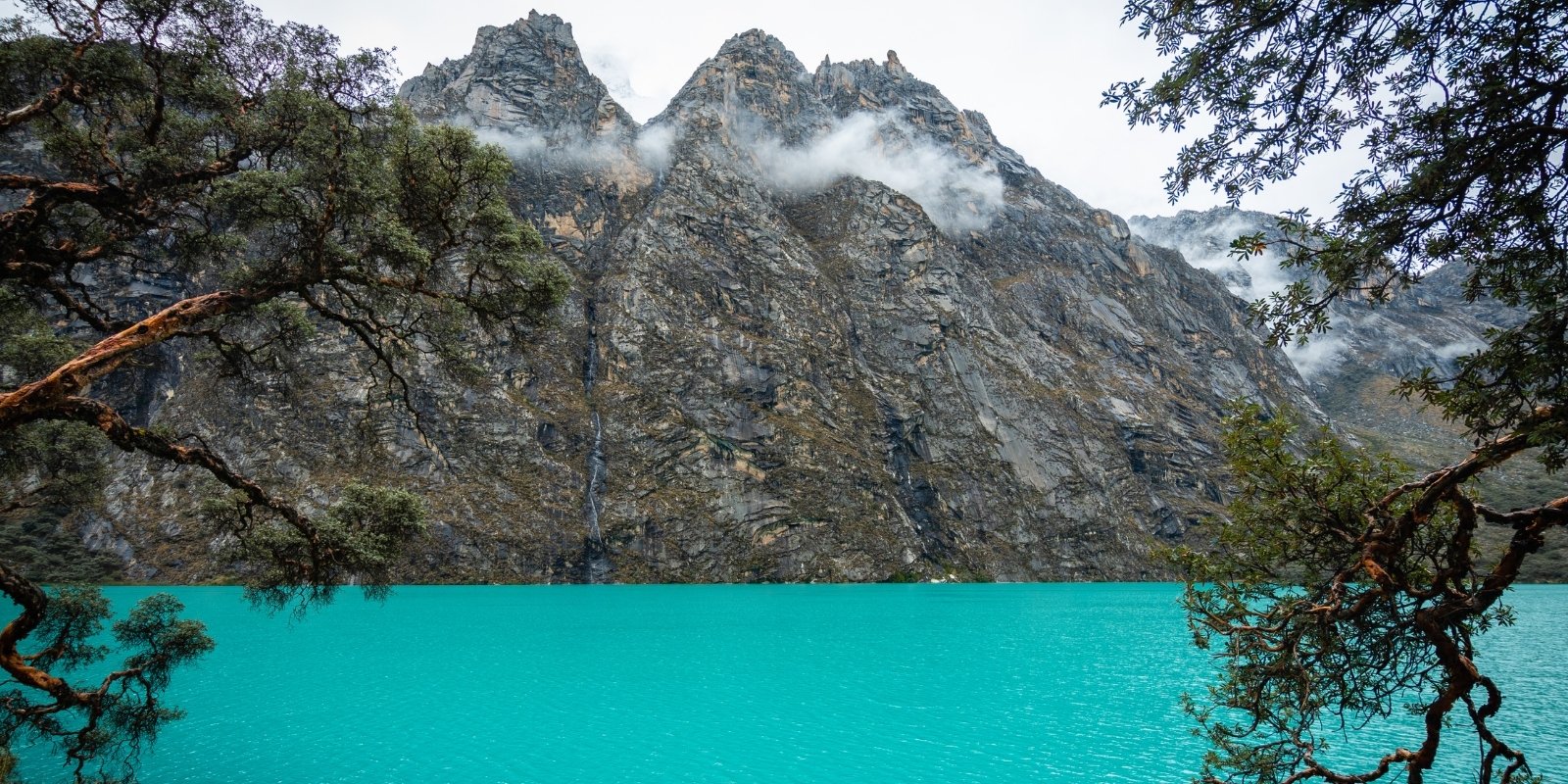
The Santa Cruz Trek is one of the most popular and accessible hiking trails in the Cordillera Blanca, in the Peruvian Andes, near Huaraz. This circuit, which typically takes 4 days and 3 nights, offers a perfect combination of spectacular landscapes, including towering snow-capped mountains, crystal-clear lagoons, and verdant valleys. Unlike the demanding Huayhuash, the Santa Cruz is ideal for intermediate hikers, with altitudes ranging from 2,900 to 4,750 meters above sea level, with Punta Unión (4,750 meters) being its highest point.
The trail passes through iconic locations such as Laguna Ichiccocha and Jatuncocha, known as the “twin lagoons” for their scenic beauty, as well as the Alpamayo Valley, where you can admire the snow-capped mountain of the same name, considered one of the most beautiful in the world. The route also offers panoramic views of other iconic peaks such as Taulliraju (5,830 m) and Quitaraju (6,040 m). The diversity of ecosystems, from Queuña forests to high Andean páramos, enriches the experience with sightings of local wildlife, such as vizcachas and condors.
Although the Santa Cruz Trek is less demanding than other routes in the region, it still requires prior acclimatization to avoid altitude sickness. It can be done independently or with local agencies, which provide guides, muleteers, and camping equipment. Its combination of accessibility, stunning landscapes, and variety of attractions makes it one of the best options for those who want to explore the majesty of the Cordillera Blanca without embarking on extreme routes.
Huascarán National Park: Located in the Cordillera Blanca (Áncash, Peru), Huascarán National Park is a protected area covering 340,000 hectares and home to imposing snow-capped peaks such as Huascarán (6,768 m)—the highest mountain in Peru—as well as turquoise lagoons, deep ravines, and a diverse array of Andean flora and fauna. Declared a World Heritage Site by UNESCO and part of the Biosphere Reserve, it is a paradise for trekking, mountaineering, and ecotourism. Its high Andean ecosystem protects species such as the condor, the vicuña, and the puya Raimondi, making it an essential destination for nature and adventure lovers.
Punta Union Pass: Punta Union Pass (4,750 m) is the highest and most emblematic point of the Santa Cruz Trek in the Cordillera Blanca, Peru. It stands out for its impressive natural viewpoint offering panoramic views of snow-capped peaks such as Taulliraju (5,830 m), Alpamayo (5,947 m), and Artesonraju (6,025 m). This challenging pass, surrounded by glacial landscapes and high Andean lagoons, marks the climax of the route and requires good physical fitness and acclimatization, but rewards with one of the most spectacular panoramas of the Peruvian Andes. Its crossing connects the Huaripampa and Taullicocha valleys, representing an unforgettable highlight for hikers.
Alpamayo Valley: The Alpamayo Valley, located in the Cordillera Blanca within Huascarán National Park, is famous for its Alpamayo snow-capped peak (5,947 m), considered “the most beautiful mountain in the world” for its perfect pyramidal shape and impressive ice walls. This valley, surrounded by crystalline lagoons like Jatuncocha and Ichiccocha, is a key destination for trekking and climbing, featuring on routes like the Santa Cruz Trek for its high mountain landscapes and Andean biodiversity. Its remote access and glacial environment make it a paradise for adventurers seeking unspoiled landscapes and challenges in the Peruvian Andes.
Jumping off point: Village of Cebollapampa near to Huaraz
Duration: 1 Day (5 hours)
Distance: Approx. 8 miles (13 km)
Rating: Challenging
Elevation: Between 12,795 feet (3,900- meters) and 15,092 feet (4,600 meters)
The hike to Laguna 69 is one of the most popular and spectacular routes in the Cordillera Blanca, located within Huascarán National Park, near Huaraz. This day trip takes visitors through stunning Andean scenery, including waterfalls, rocky gorges, and high-altitude grasslands, to reach the lagoon, known for its intense turquoise color and the reflection of the surrounding snow-capped mountains such as Chacraraju and Pisco. At an altitude of 4,600 meters, the hike is moderately demanding, requiring good acclimatization to avoid altitude sickness.
The trek begins in the village of Cebollapampa and lasts approximately 3 to 4 hours, passing by Laguna Orconcocha and traversing varied terrain, from quenual forests to glacial moraines. The final, steepest stretch takes hikers directly to the shore of Laguna 69, where the glacial landscape and the silence of the mountains create an unforgettable experience. Many visitors take the opportunity to rest by the lagoon, take photographs, or even enjoy a short picnic before descending.
Although not technically difficult, the hike requires good physical condition due to the altitude and uneven terrain. It is recommended to bring warm clothing, sunscreen, plenty of water, and energy snacks, as there are no services along the route. The best time to do it is during the dry season (May to September), when the skies are clear and weather conditions are more stable. Laguna 69 is, without a doubt, one of Peru’s natural gems and an unmissable experience for trekking and nature lovers.
Jumping off point: Arequipa
Duration: 2-3 Days
Distance: Approx. 10.6 miles to 18.4 miles (17 km to 30 km)
Rating: Challenging
Elevation: Between 7,086 feet (2,160 meters) and 11,800 feet (3,597 meters)
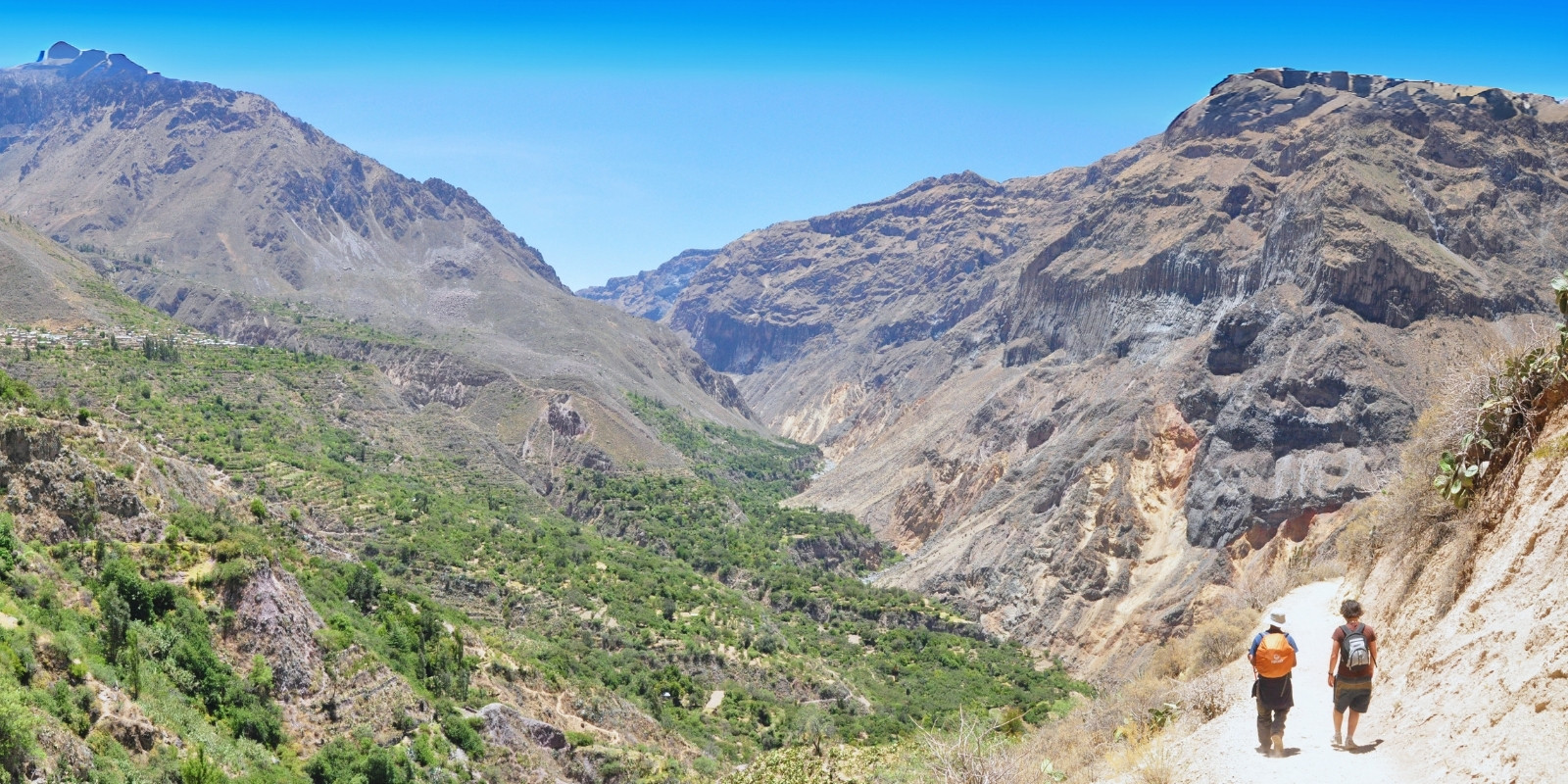
The Colca Canyon Trek is one of Peru’s most fascinating experiences, taking adventurers to explore one of the deepest canyons in the world, at 3,400 meters deep. Located in the Arequipa region, the trek offers spectacular views of pre-Inca agricultural terraces, colonial towns like Chivay and Cabanaconde, and the majestic flight of the Andean condor at the Cruz del Cóndor Lookout. The contrast between the steep cliffs, the Colca River, and the snow-capped mountains in the background creates a unique and breathtaking landscape.
The trek typically lasts two to three days, with routes that descend to the bottom of the canyon, where the Sangalle Oasis is located, a haven of vegetation and crystal-clear pools ideal for resting. The return climb is demanding, especially due to the elevation gain and the heat during the day, but the reward is the starry nights in the canyon and the interaction with local communities that maintain ancestral traditions. Good physical condition and prior acclimatization are recommended, as some areas exceed 3,200 meters above sea level.
In addition to its impressive geography, the Colca Canyon Trek allows you to immerse yourself in the culture of the Collaguas and Cabanas, ethnic groups who inhabit the area and preserve their customs, traditional costumes, and festivities. The region is also home to vicuñas, alpacas, and a variety of birds, making it a perfect destination for nature and adventure tourism. The combination of extreme landscapes, living history, and physical challenge makes this trek an unforgettable experience in southern Peru.
The Condor’s Cross: This is the most famous viewpoint in the Colca Canyon (Arequipa, Peru), known for offering spectacular sightings of the Andean condor in flight. Located at 3,287 meters above sea level, this vantage point allows you to admire the depth of the canyon (more than 1,200 meters in this area) and the contrast between the rocky walls and the Colca River. The place is ideal for witnessing the condors’ morning ritual, which takes advantage of the thermal currents to soar over the abyss, creating a unique natural spectacle. From here, you can also see snow-capped mountains such as Mismi (the source of the Amazon River) and pre-Inca agricultural terraces.
Sangalle: The Sangalle Oasis, known as “the jewel of the Colca,” is a picturesque town located at the bottom of the Colca Canyon (Arequipa), characterized by its lush vegetation, palm trees, and crystal-clear water pools that contrast with the canyon’s arid landscape. This remote refuge, located at 2,100 meters above sea level, is the final destination for the descent trek from Cabanaconde and an ideal place to rest before the demanding return ascent, offering rustic accommodations, starry nights, and an atmosphere of absolute tranquility amidst nature.
Wititi Dance: The Wititi dance originates from the Colca Valley (Arequipa). This traditional dance, associated with courtship, is characterized by the colorful attire of the dancers, who wear embroidered skirts and hats with ribbons, imitating women’s attire as part of its symbolism. To the rhythm of huaynos and with agile movements, it represents the love game between young people and is deeply linked to the agricultural and religious festivities of the region, keeping the identity of the Collagua peoples alive.
Salinas y Aguada Blanca National Reserve: This is a protected area of 366,936 hectares that houses high Andean ecosystems, including volcanoes such as Misti and Ubinas, lagoons such as Salinas (famous for its flamingos), and plains inhabited by vicuñas, alpacas, and condors. This reserve, key to the conservation of biodiversity and water recharge in the region, is also a destination for nature tourism, with trekking routes, whale watching, and wildlife sanctuary. fauna and surreal landscapes of wetlands and rock formations, all in an environment that exceeds 4,000 meters above sea level.
Jumping off point: Chachapoyas
Duration: 2-3 Days
Distance: Approx. 7.4 miles (12 km)
Rating: Moderate
Elevation: Between 5,900 feet (1,800 meters) and 9,842 feet (3,000 meters)
The Kuélap and Gocta Falls Trek is an exciting adventure that combines history, nature, and culture in the Amazon region of Peru. The hike begins by exploring the impressive Kuélap fortress, known as the “Machu Picchu of the North,” built by the Chachapoyas culture. This archaeological site, located high on a mountain, offers panoramic views and a rich pre-Incan history.
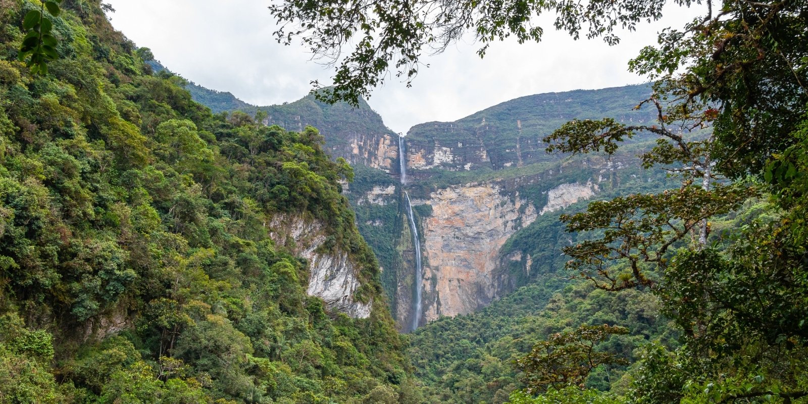
The tour continues to the majestic Gocta Falls, one of the highest waterfalls in the world, with two drops totaling 771 meters. The trek to the falls passes through cloud forests teeming with biodiversity, where you can observe exotic birds and unique flora. The arrival at the base of Gocta is an unforgettable spectacle, with its imposing curtain of water and the surrounding jungle environment.
This experience is ideal for ecotourism and archaeology enthusiasts, as it combines moderate hiking with the exploration of historical sites and natural landscapes. The trip also includes interaction with local communities, who share their traditions and lifestyle. The Kuélap and Gocta Falls Trek is a unique opportunity to discover the lesser-known but equally fascinating beauty of northern Peru.
Kuelap: Kuelap is an imposing pre-Inca fortress built by the Chachapoyas culture around the 11th century AD, located atop a mountain at 3,000 meters above sea level in the Amazonas region of Peru. Known as the “Machu Picchu of the North,” this archaeological complex stands out for its massive stone walls up to 20 meters high, more than 400 circular structures decorated with geometric friezes, and its strategic location overlooking the Utcubamba Valley. Kuelap was a political, religious, and military center, and its layout suggests it was protected from invasion. Rediscovered in 1843, it is now accessed by cable car or hike, offering a fascinating mix of history, architecture, and spectacular landscapes of the Peruvian mountainous jungle.
Cable Car to Kuelap: The cable car to Kuelap is a modern transportation system inaugurated in 2017 that allows you to comfortably reach the fortress in just 20 minutes, avoiding the winding ancient road. With cabins offering panoramic views of the Amazonian Andes, the 4-km tour departs from the Nuevo Tingo station (at 2,200 meters above sea level) to the La Malca station (at 2,900 meters above sea level), significantly reducing access time. From there, it’s a 1.5-km walk (30-40 minutes) along a well-marked trail to the entrance of Kuélap, making it easy to visit this impressive archaeological site. The cable car operates from Tuesday to Sunday and has boosted tourism in the region, combining comfort with natural and cultural experiences.
Gocta Falls: The Gocta Falls, located in the Amazonas region of Peru, are an imposing waterfall with two drops totaling 771 meters in height, considered one of the highest in the world. Surrounded by dense vegetation and cloud forests, this natural wonder was internationally recognized in 2006 and is part of the Chachapoyas ecotourism circuit. Access is via a 2.5- to 3-hour trek (5 km round trip) from the town of Cocachimba, passing through trails with spectacular viewpoints, exotic flora, and possible sightings of endemic birds. Its imposing two-tiered waterfall and its mystical setting—associated with local legends—make it a must-see destination in northern Peru.
Cocachimba: The town of Cocachimba, located two hours from Chachapoyas in the Amazonas region, is the gateway to the majestic Gocta Falls. This picturesque and peaceful hamlet, surrounded by mountains and lush vegetation, relies primarily on tourism and agriculture, offering rustic accommodations and restaurants serving local cuisine. The trails to Gocta depart from here, and its inhabitants preserve the legend of the waterfall, linked to a mermaid and a mystical charm. Cocachimba is an ideal destination for those seeking nature, authentic culture, and adventure in the heart of the Amazonian Andes.
Jumping off point: Cusco
Duration: 1 Day
Distance: Approx. 7.4 miles (12 km)
Rating: Moderate
Elevation: Between 6,560 feet (2,00 meters) and 8,858 feet (2,700 meters)
The 2-Day Inca Trail Hike is a condensed yet immersive version of the iconic trek to Machu Picchu, designed for travelers with limited time who still want to experience the magic of this ancient path. This shorter route covers approximately 12 kilometers and combines a day of moderate hiking with a guided tour of Machu Picchu on the second day. Unlike the classic 4-day trek, it doesn’t include high-altitude camps, but it retains the essence of the original trail, featuring Inca staircases, lush cloud forests, and lesser-known archaeological sites like Wiñay Wayna.
The adventure begins with the pickup from your hotel in Cusco, then by train from Ollantaytambo to Km 104 (Chachabamba), where hikers embark on a scenic trail leading to the stunning ruins of Wiñay Wayna, known for its terraced fields and ceremonial fountains. From there, the path ascends to Inti Punku (Sun Gate), offering the first breathtaking panoramic view of Machu Picchu. The first day ends in Aguas Calientes, where travelers rest overnight. On the second day, an early morning bus takes the group to Machu Picchu for a comprehensive guided tour, exploring key sites like the Temple of the Sun, the Main Plaza, and the Intihuatana stone, before returning to Cusco by train.
This trek is rated moderate, with steep sections and Inca stone steps, but it’s manageable for most active travelers. Booking with a licensed tour operator is mandatory, as permits are required. Pack essentials like sturdy hiking shoes, layered clothing, rain gear, and insect repellent. While shorter, the 2-day hike delivers a perfect blend of adventure, history, and the unforgettable reward of entering Machu Picchu through the Sun Gate just like the ancient pilgrims. Ideal for those seeking a taste of the Inca Trail without the multi-day commitment!
Chachabamba Ruins: The Chachabamba Ruins are an Inca archaeological site located at km 104 of the railway to Machu Picchu, near the start of the Short Inca Trail. This complex, situated at 2,170 meters above sea level, consists of agricultural terraces, ritual fountains, and carved stone structures, which would have served as a ceremonial center and checkpoint on the route to the sacred city. Its name means “plain between mountains” in Quechua, and its design includes a central altar with water channels, linked to purification rituals.
Wiñay Wayna Site: The ruins of Wiñay Wayna (“Forever Young” in Quechua) are one of the most impressive archaeological sites on the Inca Trail, located just 5 km from Machu Picchu. This complex, built on a steep hill at 2,650 meters above sea level, stands out for its semicircular agricultural terraces, ceremonial fountains, and finely carved stone buildings, organized into ritual and residential areas. Wiñay Wayna would have functioned as a religious and resting place for pilgrims on their way to Machu Picchu, and its strategic location offers spectacular views of the Urubamba Valley. Its beauty and state of preservation make it a highlight of the trek, blending Inca architecture with the sacred landscape of the jungle ridge.
Sun Gate: The Sun Gate (Inti Punku) is the most iconic viewpoint on the Inca Trail, located at 2,720 meters above sea level, from where hikers get their first panoramic view of Machu Picchu at sunrise. This stone structure, built by the Incas as a checkpoint and ceremonial sanctuary, marks the traditional entrance to the sacred city. Its name evokes its astronomical function, aligned with the sun during the equinoxes. Arriving at Inti Punku, after hours of trekking, represents the symbolic culmination of the pilgrimage, offering an exciting and photographic experience, where the mist and light of dawn envelop the ruins in a mystical aura.